Opening the map used to load every location you've ever saved, which could take a while and pull in a lot of data. The map now starts on today's locations and loads quickly — you can still switch to a week, month, year, or all time whenever you want the bigger picture.
fix
Rows added on other devices now show up in the terminal client #
Rows you created on the web or another device wouldn't appear in the terminal client (TUI) while you had it open — the grid only ever refreshed when you started editing a cell or restarted the app, so new entries from elsewhere seemed to never arrive. The TUI now checks the server for changes in the background and quietly refreshes when you're sat at the top of the list, so rows added on another device show up on their own within a few seconds. It holds off while you're mid-edit or scrolled down reading older entries, then catches up the moment you come back to the top. Claude's local cache, which the TUI also keeps in sync, had a related issue where its sync marker could skip rows created on other devices; it now tracks the server's own timestamps so those entries are no longer missed.
Adding a row while your connection briefly stalls could queue it for sync without you noticing. If the app then refreshed the list from the server before that row finished syncing, it would disappear from the view until you reopened the app. Rows with edits still waiting to sync are now kept on screen through a refresh, so what you just saved stays visible.
fix
Detect "connected but blocked" networks and switch to offline mode #
On networks that connect but don't actually reach us — airplane or hotel WiFi that only allows a few apps, captive portals — your device reports itself as online, so the app used to keep trying to reach the server and never switched to offline mode. We now actively probe reachability with a short timeout, so the app drops into offline mode promptly: your changes are saved locally and queued to sync, and the offline banner appears as it should.
Fixed a problem where rows added while offline (for example, on a plane) wouldn't appear in the list — and stayed hidden even after reopening the app — until you reconnected. The app now rebuilds the rows view from your local offline copy when there's no connection, so newly added rows are visible immediately. Your changes were always saved safely and synced on reconnect; this fixes only the display.
feature
Add and edit rows offline — they sync when you reconnect #
You can now create, edit and delete rows (and GPS points) with no connection. Changes are saved to a local store and queued; the moment you're back online they sync automatically, and edits made on your other devices flow back in. Notes search also works offline now, instantly, against a local mirror of your data. Conflicts use last-write-wins, and the full edit history remains available for recovery.
The installed app now launches without a connection. Previously, opening rows.life on an iPhone home screen while offline showed a blank screen — even though your data was cached locally, the app shell itself never loaded. The service worker now caches the app shell document and serves it for offline launches, so you can open the app and browse your cached entries with no signal.
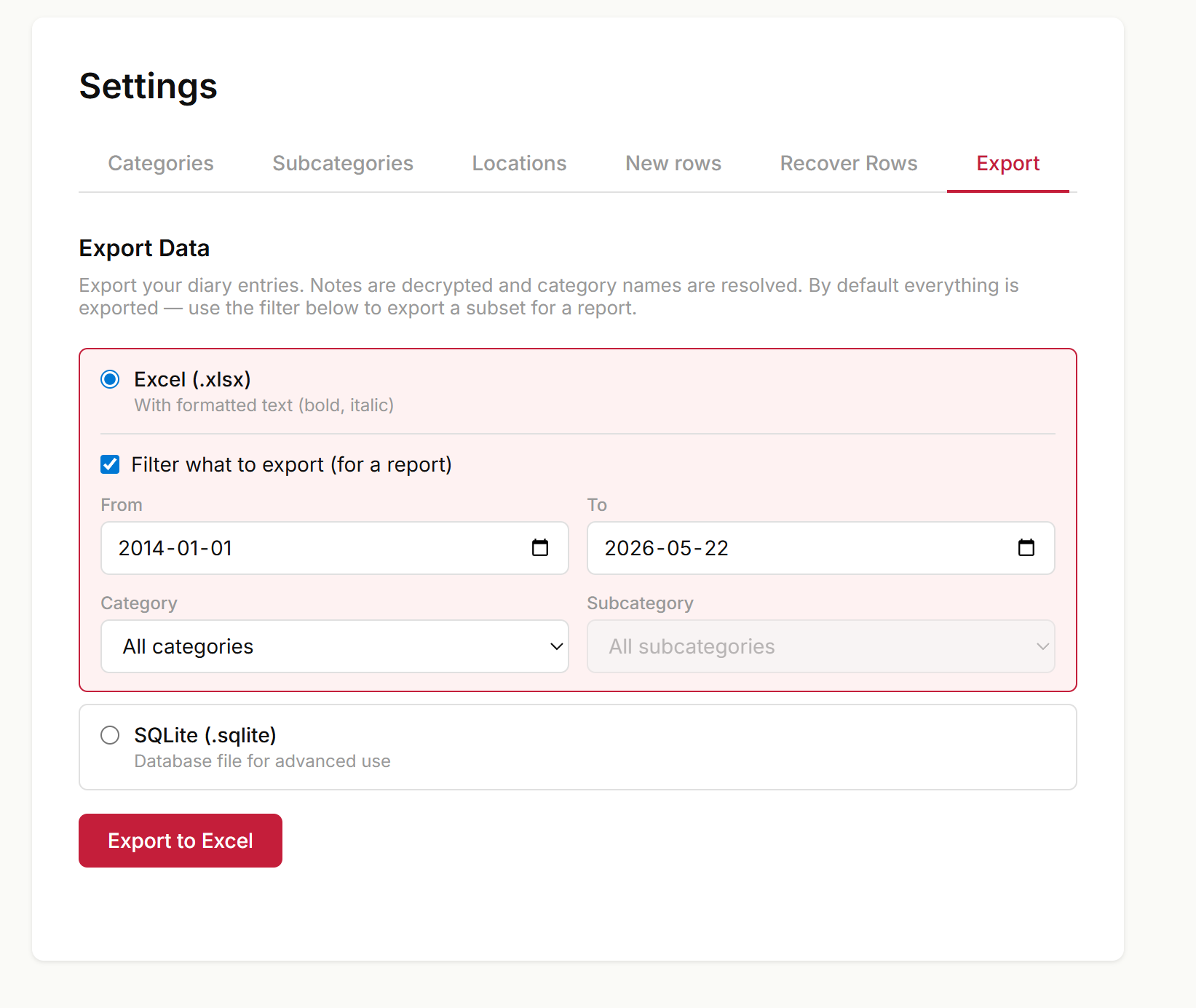
Excel export still defaults to exporting everything — a full backup — but you can now narrow it down. In Settings → Export, with Excel selected, tick Filter what to export to choose a date range and a category (optionally a single subcategory). Picking a parent category includes all of its subcategories. Handy for pulling just a client's hours or a month's entries into a report without hand-trimming the spreadsheet afterwards. SQLite export is unchanged and always exports the complete database.
The map could stall when opening a range with many thousands of GPS points (e.g. after importing a long track). It now opens smoothly: the "furthest apart" stat skips a brute-force pass, marker pins are built and inserted in bulk, and pin details are rendered only when you actually click a pin.
The Jump to heatmap on the map could show a non-zero count for a week or month that had no points to display — clicking the cell opened an empty map. This happened when a row had GPS points added manually (or imported) whose own timestamps fell outside the row's day: the heatmap counted those points under the point's timestamp, while the filter that loads the map fetches rows by the row's start time, so the two disagreed. The heatmap now buckets every point by its parent row's start time, matching what the map actually renders when you click the cell.
improvement
CLI import-gps: tell apart two phones of the same model, optionally record which one #
When you share a photo library with someone — partner, family — and you both have the same iPhone model, rows import-gps used to lump everyone's photos under the same device label ("Apple iPhone 14 Pro"), so --device couldn't separate them.
The importer now also reads the EXIF HostComputer field, which is where Apple's Camera app writes the device's user-set name (the one in Settings → General → About → Name). When present, it gets appended to the device label, so two same-model phones show up as separate entries in the device summary and you can filter them apart:
Devices found:
   1,243  Apple iPhone 14 Pro — Pablo's iPhone
     872  Apple iPhone 14 Pro — María's iPhone
      48  Apple iPhone 14 Pro
Then --device "Pablo" (case-insensitive substring) imports only yours.
There's also a new --note-device flag. Used together with --create-missing, it appends a line to each new entry's notes saying which device(s) the photos came from — e.g. "Pictures taken with Apple iPhone 14 Pro — Pablo's iPhone". Handy when you import a partner's photos and want the entry itself to remember whose camera it was, without rummaging through metadata later. The preview output shows the device suffix too, so you can see what the notes will say before committing the import.
Two caveats on the HostComputer side. It only works for photos, not videos — Apple's .mov metadata doesn't carry the device name. And it only helps if the phones have non-default names: if both are still called "iPhone", there's nothing to distinguish. Renaming a phone affects future photos only; historical ones keep whatever was set when they were shot. Photos that came through metadata-stripping services (WhatsApp, Telegram) won't carry HostComputer either.
fix
Named-location coordinates no longer leave the server in plaintext #
Named locations (your @home, @office, …) are the one place coordinates were historically stored unencrypted on the server, while everything else — notes, GPS points, category names — has always been encrypted in your browser before it leaves your device. We've been migrating those anchor coordinates under the same zero-knowledge encryption; each client quietly re-encrypts them the next time you log in.
This release closes the remaining gap: once a location's coordinates have been encrypted, the API stops returning the old plaintext copy entirely — it's dead weight the apps already ignore. Plaintext is now sent only for locations that haven't been re-encrypted yet, and solely so the migration can finish the job. We also fixed an edge case in the desktop/TUI client where a half-written record could be mistaken for "already encrypted" and skipped, leaving its plaintext stranded.
No action needed on your part, and nothing changes in how locations look or behave.
On phones, picking a specific scope (Day, Week, Month, Year) made the date stepper push the toolbar wider than the screen — the next-day arrow and the Area button got clipped off the right edge, so there was no easy way to draw an area filter. The toolbar now stacks cleanly: the scope pills and the date stepper each take their own full-width row, the date label truncates instead of wrapping, and the Area button (with its label) stays fully visible next to the category filter.
The new Filter by area rectangle didn't work on touch devices — drag-to-draw conflicts with single-finger pan, so no rectangle would ever land. Touch now uses a two-tap flow instead: tap the Area button, tap one corner of the area you want, tap the opposite corner, done. A small red dot marks the first corner so you can see what's coming, and pan/zoom stay enabled between taps so you can reposition the map.
Two related fixes on phones:
The Area button was getting clipped at the right edge of the toolbar because the category dropdown's flex-grow pushed it off — now icon-only on phones and flex-shrink-0 so it always stays visible.
The draw-mode hint no longer talks about pressing Esc on touch (there's no Esc key); it now shows a Cancel button alongside the instruction.
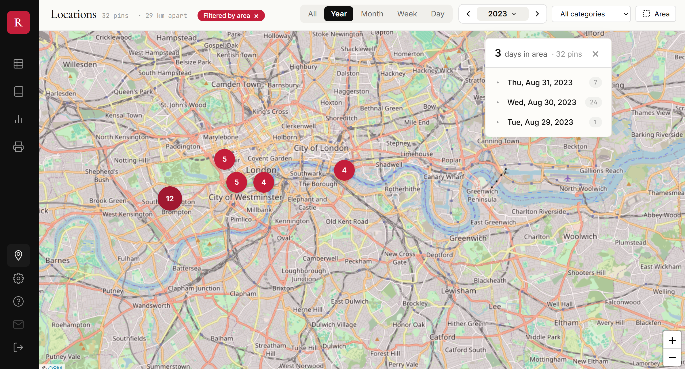
A new Area button in the map toolbar lets you drag a rectangle on the map. Once drawn, only locations inside that rectangle show up — date scope and category filters still apply on top, so you can ask things like "how many days did I spend in London in 2023?" with one selection.
A Locations panel appears alongside the map listing the distinct days you've been in the selected area, with the per-day pin count. Click a day to expand its entries; click an entry to pan the map to that point. The headline number — N days in area — is the simplest honest answer to "how often have I been there?"
On mobile, the panel becomes a second tab next to the map (only visible while a filter is active). The mobile toolbar also got a small layout fix: km apart no longer gets clipped at the right edge of the screen.
Press Esc while drawing to cancel; click the Filtered by area chip in the toolbar to clear an active filter.
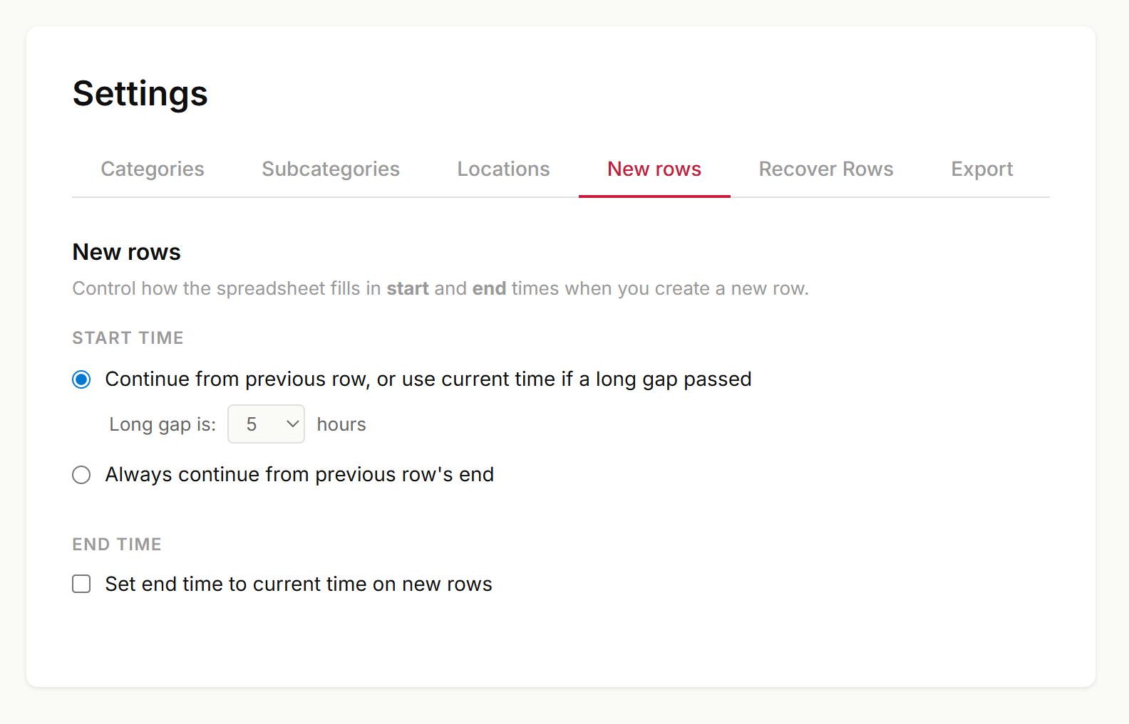
Settings has a new New rows tab that turns previously hardcoded behavior into preferences that sync across devices.
Start time
The default still applies — when you add a row at the bottom of the sheet and a long gap has passed since your last entry, the new row jumps to the current time instead of continuing from where the previous one ended (introduced in PR #12 with a hardcoded 5-hour threshold). You can now:
Pick the threshold yourself (1–24 hours).
Or turn the behavior off entirely — every new row starts from the previous row's end, no matter how long ago that was.
End time
New: opt in to set end time to current time on new rows. Off by default. When on, every new row is created with both start and end already filled in — useful if you mostly track tasks you've just finished.
Everything is stored per-account and applies on web today, with TUI and mobile to follow.
When you have Set end time to current time on new rows turned on, pressing Enter repeatedly on a blank row at the bottom of the sheet used to create a stack of zero-duration rows with timestamps marching into the future and the focused row jumping a couple of positions up between presses.
Now: if the bottom row has no category, no subcategory and no notes, pressing Enter is a no-op — the cursor stays put on the row that's still waiting to be filled in. Once you've filled in any of those three fields, Enter creates a new row again as before, and the new row's end time is clamped so it never sits before its start.
fix
Settings and Analytics tabs no longer get clipped on mobile #
Adding the new New rows tab pushed the Settings tab bar past the edge of the screen on phones — the rightmost tabs (and the page content) ended up cut off. Same thing was already happening to the Admin Analytics page once it grew to seven tabs.
On narrow viewports, tabs now wrap onto a second row with a pill-style active highlight, so every section is reachable without horizontal scrolling. Desktop layout is unchanged.
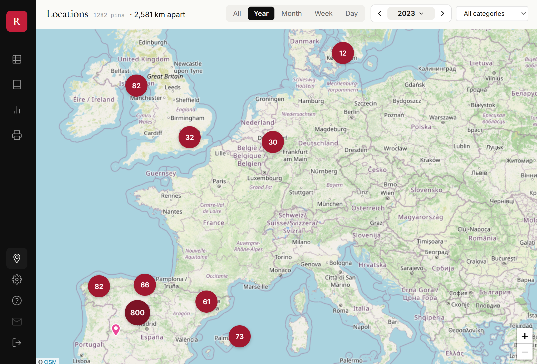
The map toolbar now shows a small X km apart stat right next to the pin count — the great-circle distance between the two furthest GPS points in whatever date range you have selected. Switch from Year to Month to Week and watch it shrink as the trips fall out of view.
It's the simplest honest answer to "how far did I get this year?" Picking diameter rather than path-length sidesteps the trap of pretending we know the route between sparsely-tagged points: a single Madrid pin and a single Tokyo pin from the same trip would otherwise read as a 10,800 km straight-line jump even though we have no idea what was traveled in between. X km apart just states the geographic fact about two points the user actually tagged, with no claim about routes.
Hidden when there are fewer than two points or the spread is under 1 km — a stay-at-home week stays clean, a trip across Europe lights up.
The in-app messages system now supports single-choice questions, not just announcements with a CTA button. When a message has options attached, the popup renders them as chips — picking one records the response and dismisses the message in a single click.
First use of it: a one-question survey for users with 5+ days of tracking, asking whether they'd prefer the End column to fill automatically with the current time when creating a new row.
feature
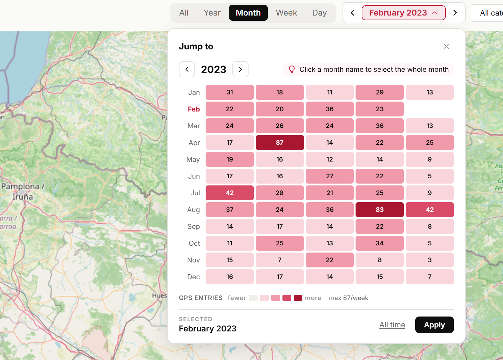
Jump to any week on the map — new scope filter with GPS heatmap #
The map's date filter has been rebuilt around a single question: which week should I be looking at? The old All time dropdown is gone; in its place there's a scope bar with All · Year · Month · Week · Day pills, a prev/next stepper for the current scope, and a new heatmap popover for jumping across years.
Scope pills + stepper. Pick the granularity once; the ◀ label ▶ arrows step ±1 of whatever scope you're in — next week, previous month, next year. One click, no re-selection.
Heatmap popover for big jumps. Click the label to open a 12-month × 5-week grid for the selected year. Each cell is colored by how many GPS entries landed in that week — so a week spent in Madrid lights up dark, a quiet week at home stays pale. The exact count is printed inside every cell (847, 2.4k, 16k) so you can triple-check what you're looking at.
Click a cell → filter to that specific week
Click a month name on the left → filter to the whole month
Arrows at the top of the popover → switch years without touching the map; hit Apply to commit, or click a cell/month to apply in one step
Day scope swaps the heatmap for a regular month calendar — click any day to filter to it, including a Today shortcut.
Quieter data loading. Navigating years inside the popover is staged — the map only reloads when you actually apply a selection, so scrubbing back through 2014 → 2015 → 2016 doesn't trigger a cascade of fetches. Each year's heatmap density is fetched once and cached.
The heatmap counts individual GPS points (not rows), so it matches exactly what the map shows when you zoom in — a row with a full day of auto-tracking contributes all of its points to the week, not just one.
fix
Fix: clicking outside the grid no longer steals focus #
Clicking or selecting text in side panels, filters, or any area outside the spreadsheet grid would immediately lose focus and snap back to the grid, making it impossible to interact with other parts of the UI. The grid's focus-recovery logic (designed to handle cells removed by virtualization during scrolling) was too aggressive — it reclaimed focus on every focusout event, even when the user intentionally clicked elsewhere. Now focus is only reclaimed when a cell disappears due to virtualization, not when you deliberately click outside the grid.
The edit dialog in the terminal client now uses Ctrl+S to save and close (previously Ctrl+Shift+Enter, which caused issues with some terminal emulators). Enter continues to insert newlines for multi-line notes.
March 2026
improvement
TUI: improved edit dialog shortcut and Ctrl+E from new rows #
Two quality-of-life improvements for the terminal client:
Ctrl+Shift+Enter now saves and closes the edit dialog (was Ctrl+Enter, which conflicted with some terminal emulators). Plain Enter inserts a newline as before.
Ctrl+E works while typing — you can now press Ctrl+E while editing any cell (including a brand new row) to open the full multi-line edit dialog. Previously you had to finish editing first, then press Ctrl+E separately.
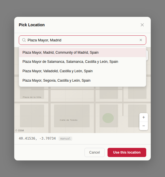
You can now search for an address or place name when picking a location. The search bar in the location picker dialog uses Mapbox geocoding to find places and jump to them on the map.
fix
Fix: filtered rows view no longer breaks on tab switch #
When using a notes filter (text search) in the rows view, switching to another window and coming back would blank the screen and show an incorrect row count. The background refresh was overwriting the client-side filtered results with unfiltered server data. Now the refresh is skipped when a notes filter is active, preserving the filtered view across tab switches. Also fixes the scrollbar shaking that could occur with active filters.
fix
Fix mobile notes scrolling when keyboard is open #
Fixed an issue where scrolling through long notes on mobile caused the UI to shake, making it impossible to reach content hidden behind the keyboard.
Adding a location to an entry that already had one resulted in duplicate GPS points with no way to remove them. The agent and MCP integration now support a delete_locations tool that removes all GPS points from an entry.
To fix a wrong location: ask the agent to delete the location, then add the correct one.
The daily and weekly stats panels now show the day-of-year number next to the date and the ISO week number next to the week label. For example, Sat, Mar 28 (87) means it's day 87 of the year, and THIS WEEK (13) means ISO week 13. Displayed in both desktop and mobile stats views.
feature
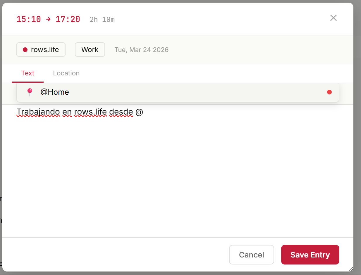
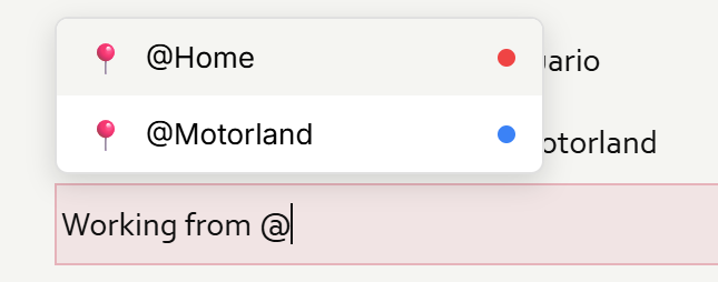
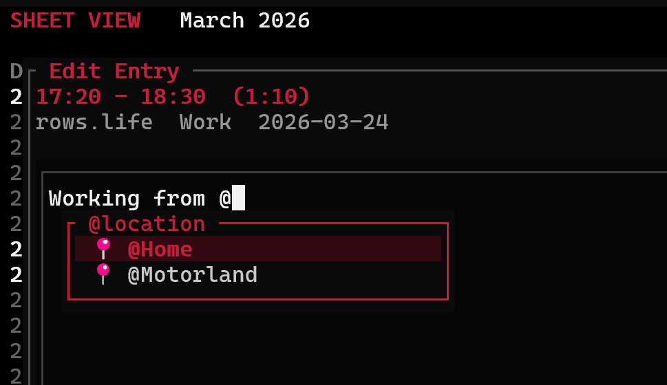
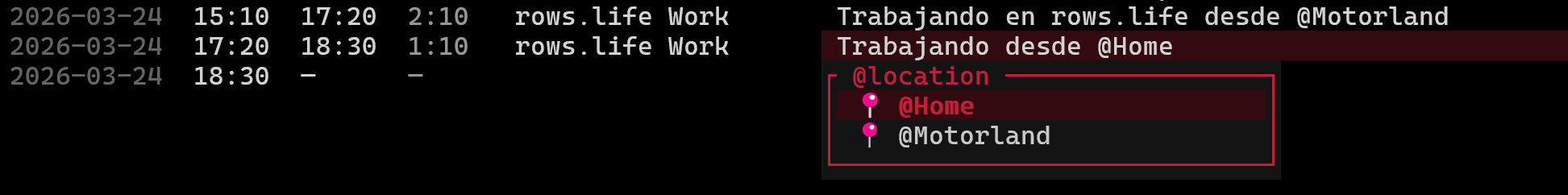
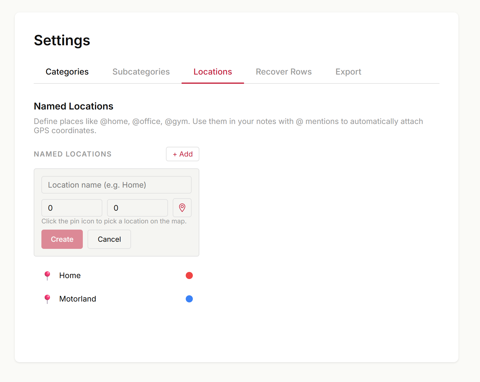
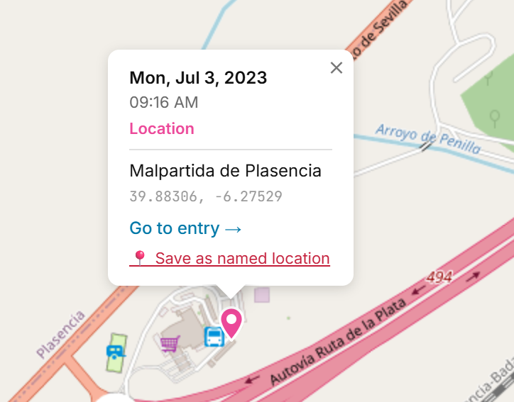
Named locations — bookmark places and use @mentions #
You can now save frequently-used places like @Home, @Office, or @Gym and reference them with a simple @ mention in your notes. Selecting a location automatically attaches GPS coordinates to the entry.
Three ways to create named locations:
Settings > Locations tab — manage all your places with name, emoji, color, and a map picker for coordinates
Map view — right-click or long-press anywhere on the map to save that spot, or click "Save as named location" on an existing pin
MCP / Agent — create and use named locations via the CLI agent or Claude Desktop
@ autocomplete everywhere:
Type @ in the notes field (rows view, edit dialog, or mobile) and a dropdown appears with your saved locations
Arrow keys to navigate, Enter to select — GPS is attached instantly
Works in the terminal TUI too (both inline editing and Ctrl+E edit view)
The rows agent and MCP integration can now edit existing entries and add GPS locations — two capabilities users had been asking for.
Edit entries — Change the start/end time, category, subcategory, or notes of any entry. Only the fields you mention get updated; everything else stays as-is. No more deleting and recreating entries just to fix a typo.
Add location — Tag any entry with GPS coordinates by telling the agent where it happened (e.g. "add Madrid as the location for that entry"). Coordinates are encrypted client-side, consistent with our zero-knowledge model.
The delete row shortcut on macOS is now ⌘+Backspace, matching the standard macOS convention. Previously it required ⌘+Delete (forward delete), which many Mac keyboards don't have as a dedicated key. Windows and Linux shortcuts remain unchanged (Ctrl+Delete).
You can now delete time entries through the MCP integration and the rows agent. Claude can find and soft-delete entries on your behalf — deleted entries can be recovered within 30 days.
Use search or filter tools to find the entry first, then ask Claude to delete it.
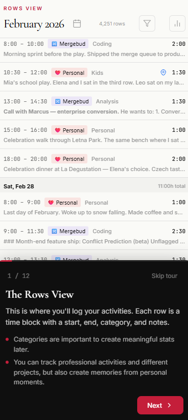
New users now see a Take the tour button when they first log in, instead of a blank screen. The tour loads real demo data (2 years, 4,260 entries from a fictional Czech programmer) and walks you through every feature in 12 steps:
Rows View — how time entries work, categories, day and week stats
Statistics — activity overview, category breakdown, year in review
Diary — turning your data into a readable journal
Map — reliving holidays and places you visited
Settings — customizing categories with emojis and colors
Print — creating printed memory books
The tour works on both desktop and mobile, with adapted layouts for each. On mobile, stats panels slide in above the tour card so you can see both. Navigate with Next/Back buttons or arrow keys.
A tour icon in the sidebar lets you restart it anytime — it pulses red if you have fewer than 15 days logged, gently reminding you to explore.
feature
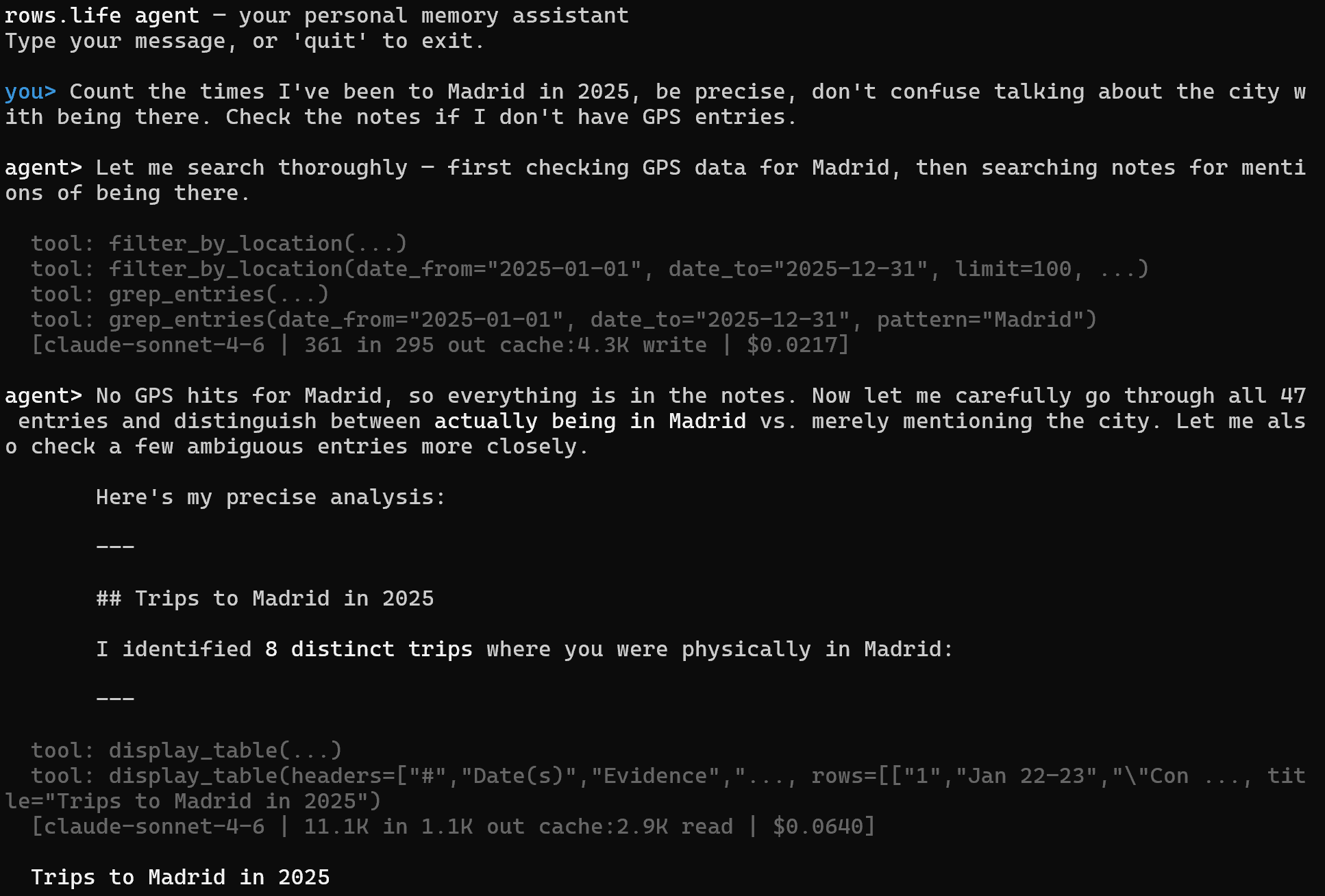
New: rows agent — your personal AI memory assistant #
Introducing rows agent — a conversational AI assistant that lives in your terminal and turns your rows.life data into a queryable personal memory. This is an early proof of concept that connects directly to the Anthropic API.
What it can do:
Extended memory — Ask questions about your life data: "When did I last go to Madrid?", "How much time did I spend on project X this year?", "Show me my gym frequency by day of the week"
Interview mode — Say "help me log my day" and the agent will conversationally help you fill in your rows, inferring times and categories from your narrative
Visual output — The agent can render tables, bar charts, and even Mapbox maps directly in your terminal
Semantic + GPS search — Combines text search, semantic embeddings, and GPS bounding-box queries to find entries
Smart enough to reason: With Claude Sonnet, the agent can distinguish between talking about Madrid in your notes vs. actually being there, cross-referencing GPS data with note content to give precise answers.
How to try it (requires your own Anthropic API key):
This is a proof of concept — the final product won't require you to bring your own API key. We're using it to learn what makes a great AI-powered life memory interface.
Press Ctrl+N in the terminal client to instantly set the current row's end time to right now. Perfect for when you start tracking a task and want to close it out without typing the time manually. Only works on rows that don't already have an end time. Works the same on macOS, Windows, and Linux.
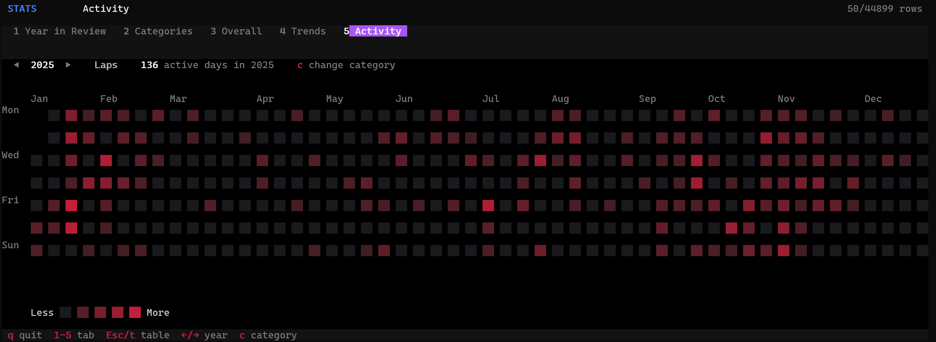
The terminal client now includes a GitHub-style activity heatmap (tab 5 in Stats). See your active days per category at a glance, navigate years with arrow keys, and filter by category or subcategory with the 'c' picker.
feature
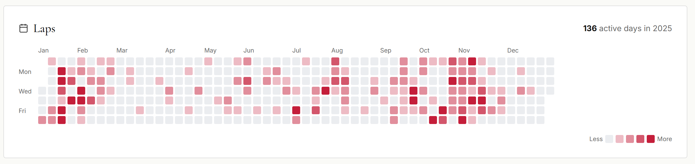
Activity graph: see your active days per category #
The category detail view now includes a GitHub-style activity graph showing how many days you were active in each category throughout the year. Darker squares mean more hours tracked that day, making it easy to spot patterns, streaks, and gaps at a glance.
The home page now showcases all features in an interactive carousel with seven tabs: Log, Analyze, Map, Mobile, Diary, Terminal, and AI. Each tab has multiple slides with screenshots and descriptions. Click any image to open a fullscreen lightbox with navigation across all slides. The old three-card grid has been replaced to better reflect everything rows.life can do.
The Trends chart now supports tracking total rows and rows with notes over time, alongside category hours. Select 'Total Rows' or 'Rows with Notes' chips to visualize how your tracking volume evolves day by day, week by week, or month by month.
The landing page feature carousel no longer auto-advances. Navigation is fully manual via arrows, dots, tabs, or swipe. Also fixed accidental slide changes on mobile when pinch-to-zoom overlapped with swipe gestures.
fix
Fix GPS points getting wrong timestamp on stopped entries #
Fixed a bug where adding a GPS location point to a stopped entry would record the entry's start time instead of the current time. This caused points to appear out of order, with newly added points jumping to the top of the list.
fix
Fix location picker constantly jumping back to current position #
Fixed an issue where the location picker map kept recentering to your GPS position on every accuracy update, making it impossible to pan to and select a different location — especially painful on mobile. The map now only auto-centers once when it gets the first GPS fix, then lets you freely browse and tap anywhere to place your pin. A new crosshair button in the top-right corner of the map lets you jump back to your current GPS position whenever you want.
rows.life now works offline. A service worker caches the app so it loads faster — especially noticeable when launching from the home screen on mobile. When you lose connection, you can still browse your previously loaded entries in read-only mode, with a subtle bar at the bottom letting you know you're offline. No data is lost — editing is simply disabled until you're back online. On the server side, a new 'updated since' endpoint enables more efficient incremental sync for the TUI/MCP client.
feature
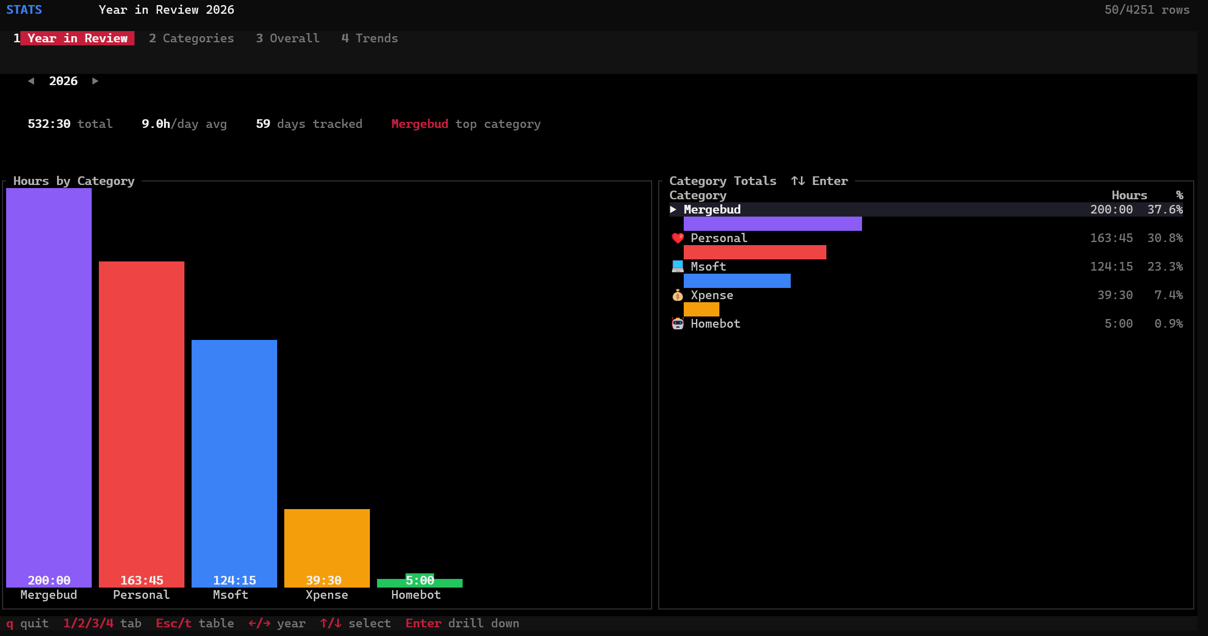
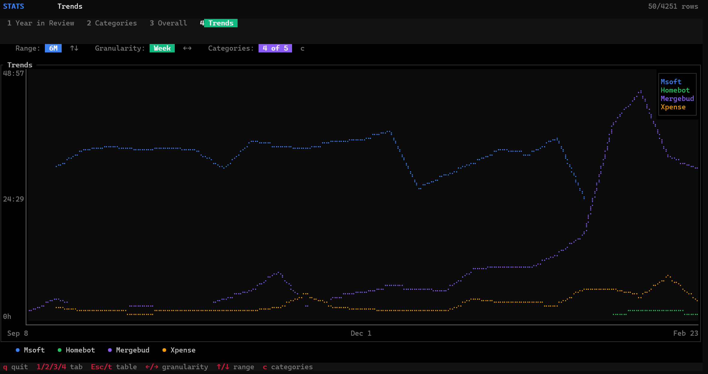
TUI stats — beautiful charts right in your terminal #
The terminal client now has a full stats module with interactive charts powered by ratatui. Press s from the table view to enter Stats mode with four tabs: Year in Review (bar chart of hours by category with drill-down into subcategories), Categories (browse all categories with all-time stats and subcategory breakdown), Overall (year-over-year comparison bar chart with summary table), and Trends (line chart with configurable date range, granularity, and category picker dialog). Navigate years with arrow keys, switch tabs with 1/2/3/4, drill down with Enter, and press c to select trend categories.
fix
Fix location points not updating in edit dialogs #
Fixed two issues with adding and removing location points in the entry edit dialog (both mobile and desktop). First, adding or removing a location point wouldn't visually update the list — the dialog appeared frozen, but the change was actually saved, so it would show up after closing and reopening. This was caused by the dialog working on a stale copy of the entry that wasn't kept in sync with the underlying data store. Second, when adding a new location point to an entry that already had one, the picker would show the existing point as a static pin instead of acquiring a fresh GPS fix. Now the picker always starts with GPS active, and all add/remove changes are reflected immediately in the dialog.
The terminal client no longer asks for your decryption passphrase when a valid cached key already exists. You'll only be prompted the first time or after a passphrase change.
Screenshots in the release notes page are now clickable — click any image to view it full-size in a lightbox overlay. Press the image or the × to close.
You can now delete entries directly from the terminal client. Press Delete or Backspace on any row and confirm with y — any other key cancels. The status bar shows the keybinding hint and a red confirmation prompt so you won't delete anything by accident.
feature
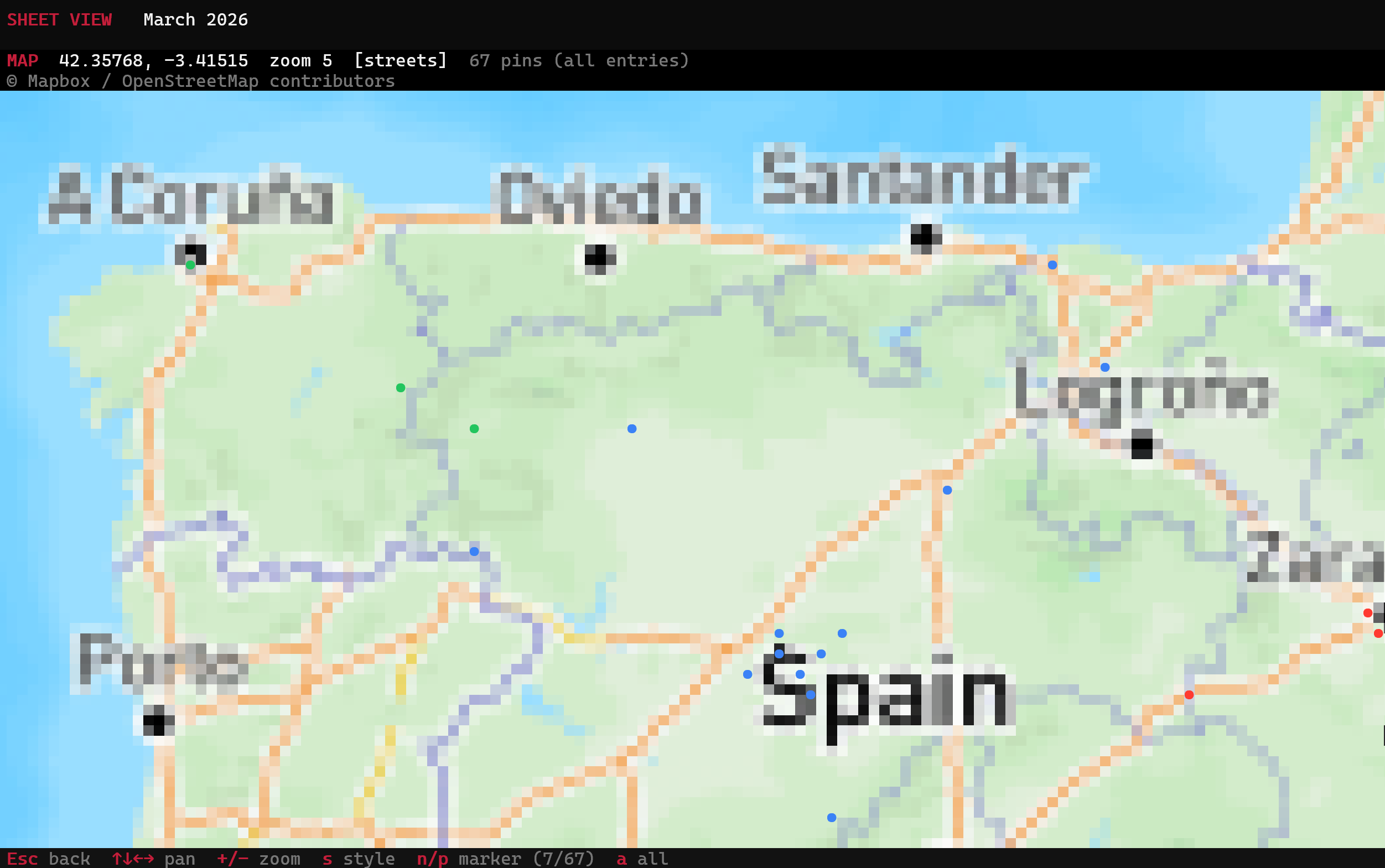
TUI map — browse your locations from the terminal #
The terminal client now renders an interactive map with all your GPS-tagged entries. Press m on any row to see its location points on a true-color Mapbox map rendered with half-block pixel art. Pins are color-coded by category, and pressing n/p cycles through markers with a label showing time and category. Press a to toggle between the selected entry's locations and all your locations (fetched live from the API). Rows with GPS data show a ● indicator in the table so you can spot them at a glance. Pan with arrow keys, zoom with +/-, and switch between six map styles with s.
feature
Multiple GPS points per entry — trace your path, not just your start #
Entries can now hold multiple GPS coordinates instead of just one. This is a big deal for anyone who moves during an entry — a morning hike, a road trip, or an afternoon of running errands across town. Each point appears as its own pin on the Map, and tapping a pin shows the exact time that coordinate was recorded alongside the row's start time. In the entry editor, a new Location tab lists all points with their timestamps, and you can add or remove individual coordinates. Combined with rows import-gps, this means every photo you took during an entry automatically becomes a pin on the map — so a 3-hour bike ride doesn't collapse to a single dot, it becomes a trail of everywhere you stopped to take a picture.
improvement
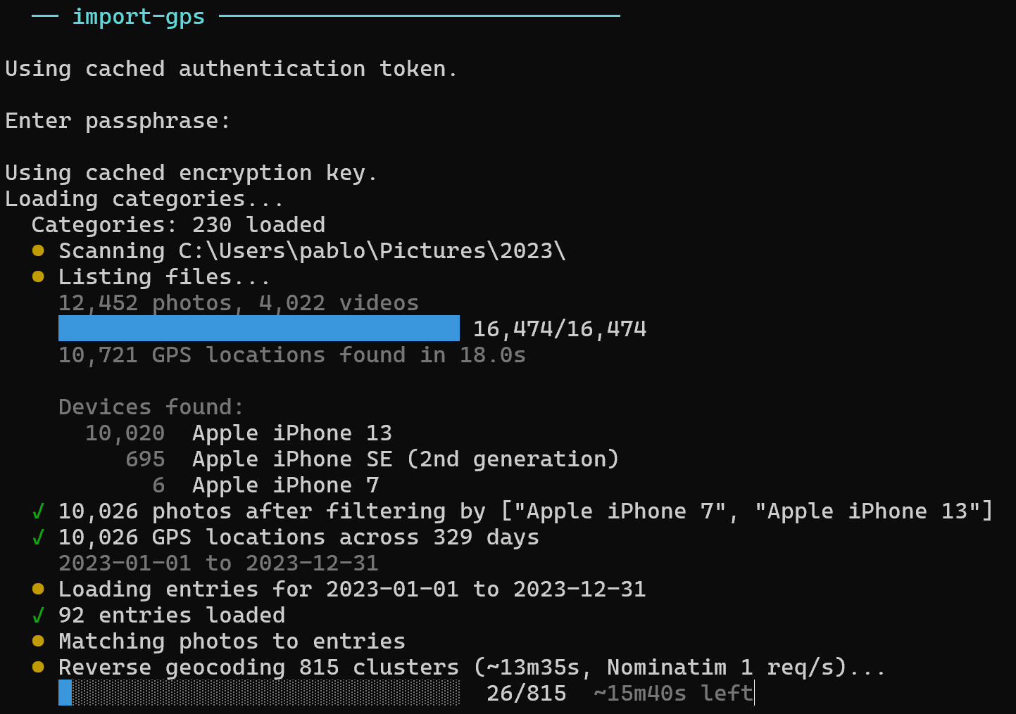
CLI: smarter GPS import with distance-based dedup and auto-created entries #
The rows import-gps command now uses real distance calculations (haversine formula) to deduplicate GPS coordinates. Photos taken within 50 meters of each other on the same entry collapse into a single point — so ten selfies at the same restaurant become one pin, not ten. You can safely re-run the import on the same photo directory: existing coordinates are checked by distance, and only genuinely new locations are added. This also means importing overlapping photo libraries (e.g. iCloud copies + local backups) won't create duplicate pins.
The --create-missing flag is now much smarter. Instead of creating one row per day, it clusters photos by time: if there's more than a 1-hour gap between consecutive photos, it starts a new entry. Each entry gets the proper start and end times from its photo cluster, all GPS points (deduplicated within 50m), and a place name automatically resolved via OpenStreetMap reverse geocoding — so instead of a blank row, you get something like "Calle Mayor, Salamanca" as the note. The entries are created under the 'Location' category.
improvement
Map: formatted notes and "Go to entry" link in popups #
Map pin popups now render text formatting — bold, italic, underline, and strikethrough are displayed correctly instead of showing raw markdown markers. Additionally, each popup now includes a "Go to entry" link that takes you straight to that day in the Log view, making it easy to find and edit the full entry.
feature
TUI: create new categories and subcategories inline #
You can now create new categories and subcategories directly from the terminal UI picker. Just start typing a name that doesn't exist yet — a '+ create' option appears at the bottom of the list. Press Enter to create it on the server and assign it to the current row in one step. Works for both parent categories and subcategories.
feature
CLI: enrich your entries with GPS locations from your photos #
You can now enrich your entries by adding GPS locations extracted from your photo collections! Since photos and videos contain GPS coordinates in their EXIF metadata, the new rows import-gps command reads them and adds the locations to your rows.
This scans all photos and videos in the directory, filters by the specified devices (your phones, not your family's), and shows a preview of which entries would be enriched — without changing anything. The command displays a summary of all camera devices found, so you can decide which ones to include.
Remove --preview to actually apply the changes. Photos are strictly matched to rows by time window: a photo only enriches a row if it was taken during that row's time range. Existing locations are never overwritten.
Use --create-missing to also create new 'Location' entries for dates where you have GPS-tagged photos but no matching row. Without it, only existing rows are enriched.
Supports JPEG, HEIC, PNG, TIFF, MOV, and MP4 files.
The visual decryption effect — where your encrypted notes unscramble into readable text as they load — is now enabled for all users. We had temporarily restricted it to a single test account while we hardened it against edge cases with contenteditable fields and virtualized scrolling. After several days of testing with zero data corruption issues, we're confident it's solid. Enjoy the crypto vibes.
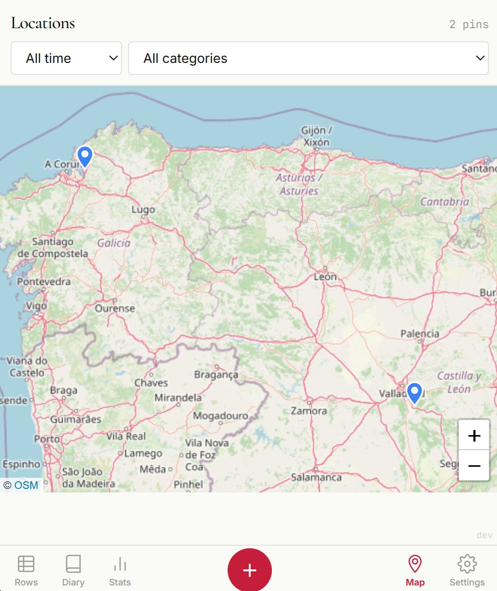
A brand new Map tab lets you visualize all your location-tagged entries on an interactive map. Pins are color-coded by category, and tapping one reveals the date, time, and notes. Filter by time range (today, this week, a specific month, or all time) and by category to answer questions like "where did I work from in February?" Pins cluster automatically when you zoom out, so even thousands of entries stay clean. As always, your coordinates are zero-knowledge encrypted — they're decrypted only in your browser.
Fixed a long-standing issue where changing a row's date or start time to a different day caused it to vanish mid-edit. The row would silently re-sort to its new chronological position, leaving you staring at a gap. Now the row stays pinned in place while you edit. When you move to another row, the view automatically navigates to the entry's new date so you can see exactly where it landed. Also fixed inserting rows between existing entries (via Ctrl+Shift+Enter or the insert icon): new rows now correctly inherit the time of the row above instead of jumping to the current date, so they stay right where you'd expect them.
Fixed a bug where reusing a pre-existing type (e.g. Rest / General) could cause it to appear as [unknown] in the stats breakdown. This happened because the app kept a stale reference to a category the server had already cleaned up. Most likely to affect accounts with only a few entries.
Removed the delete button from the mobile edit screen to free up vertical space for typing. You can still delete rows by swiping on them in the rows list.
A database permission issue caused row updates to fail for approximately 2 hours. The new row versioning table was created during a deployment but the application's database user was not granted access to it. Since row versioning runs before every save, all updates were blocked. No data was lost — rows that were already saved remained intact, but new edits during the window were not persisted. The issue has been fixed and a permission step has been added to prevent this from happening again.
fix
Fixed notes corruption caused by decryption visual effect #
Fixed a bug where the decryption visual effect could leave garbled cipher characters stuck on screen, on both desktop and mobile. When data refreshed in the background while the scramble animation was still playing (e.g. returning to the tab, or saving another entry), the animation could lose track of the original text — leaving some fields permanently showing a mix of real text and random characters. Data in the database was never corrupted by this bug; it only affected what was shown on screen. However, if you edited and saved while the garbled text was visible, the corrupted text would be saved. The fix ensures the animation properly preserves and restores original content, and adds safety checks that cancel the animation when you interact with a field.
Saving a mobile row entry now immediately reflects the changes in the rows list. Previously, edited values wouldn't appear until the page was refreshed.
Fixed an issue where row edits on mobile appeared saved locally but were lost on reload. The save button now shows 'Saving...' while the server confirms, and rolls back the UI if the save fails so you always see the truth.
Every time you update a row, the server now saves a snapshot of the previous values before overwriting. If a bug ever corrupts a row's content, the original data can be recovered from the version history. Versions are kept as long as the row exists and cleaned up automatically when a deleted row is permanently purged (30+ days after deletion). No impact on normal usage.
The filter system now works on mobile. Tap the filter icon to open a bottom sheet with category, subcategory, date range, and notes search. A crimson bar shows your active filter with one-tap clear. All five filter types from desktop are available on mobile.
New rows now use the current date and time when the gap from your last entry exceeds 5 hours. No more manually correcting the date after a night's sleep or a long break.
Optionally attach your GPS location to time entries. An interactive map picker shows where you are, and coordinates appear in both the diary view and PDF exports. Location data is encrypted with the same zero-knowledge architecture as your notes — the server only sees encrypted blobs.
Notes now support rich text formatting with bold, italic, and underline. A compact formatting toolbar appears when editing, and keyboard shortcuts (Ctrl+B, Ctrl+I, Ctrl+U) work too. What you type is what you see — true WYSIWYG editing right inside the spreadsheet row.
The diary view is now available on mobile with a dedicated single-page layout optimized for smaller screens. Browse your days as a journal, right from your phone.
New users can now explore rows.life with two years of realistic demo data (4,260 entries) before committing to their own tracking. See what long-term time tracking looks like — statistics, diary entries, and patterns — all without creating a single row.
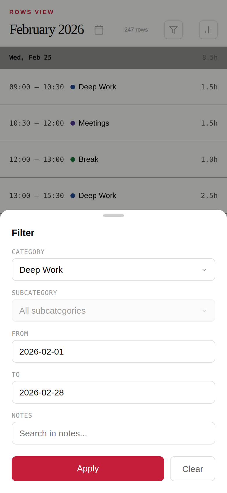
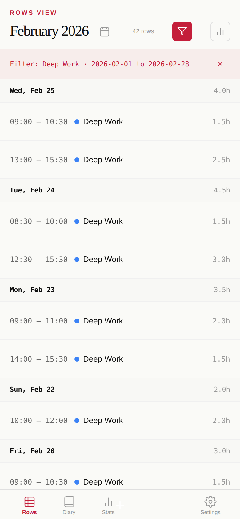
New Filter panel lets you narrow down rows by category, subcategory, and date range. Also includes full-text notes search — your encrypted notes are decrypted client-side and searched locally, so the server never sees your search queries.
You can now edit dates and manage categories directly on mobile. Categories also refresh automatically when switching devices, so changes sync across all your sessions.
Autocomplete suggestions are now ranked by usage frequency — your most-used categories and subcategories appear first. Also added the ability to reassign subcategories between categories.
Major improvements to the mobile experience: better button handling, fixed layout issues, smoother view transitions without blank screens, and landscape mode support.
The first public release of rows.life — a time tracking app with zero-knowledge encryption. Log your hours in a spreadsheet-like interface, view statistics by category, and export everything to PDF.